This Map Shows How Much Snow it Takes to Cancel School in Your State
The slightest dusting can cancel school in the South, while multiple feet are needed to get Alaskan kids out of school.

The current polar vortex might have you worrying about shoveling the sidewalk and navigating frozen roads, but it has kids across the country hoping and praying for a day off of school. How much needs to fall to make their dreams come true? An enterprising Reddit user’s map has the answer.
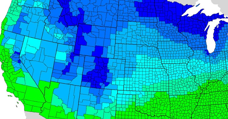
About five years ago, Alexandr Trubetskoy put out a call on the (very SFW) r/MapPorn subreddit. He asked people to let him know how much snow it usually took for schools to close in their area, interpolated it using NOAA data, and created a color-coded, county-level map of the US that shows how much needs to fall overnight to close schools the next day.
Much of what the map shows is what you’d expect. Any amount of snow (or a prediction of such) is typically enough to cancel school in the Deep South, the majority of Texas, and much of California. It doesn’t make sense for localities there to invest in the infrastructure needed to clear snow, a rare occurrence, in time for school to begin.
With the exception of northern Washington state and parts of Michigan and New York, kids who live on the Canadian border shouldn’t expect a day off any time soon. Trubetskoy’s data shows that it usually takes more than two feet of snow to close schools there.
Reddit/Alexandr Trubetskoy
To his credit, Trubetskoy acknowledges some shortcomings in his work. In the Midwest, for instance, schools are often closed for cold days in response to low wind chill and temperature instead of snow. Mountainous regions can also lead to less than perfect data, as snow accumulation on a remote summit has little to do with school closures much closer to sea level.
If there is snow in the forecast, a quick peek at the map will tell you if schools in your area are likely to close, but don’t take it as gospel. In snow day prediction, as in all other aspects of parenting, it’s best to expect the unexpected.